June 23 - San Francisco to El Granada
This morning I was really nervous. I got up at 7:40, took a shower and started packing for the bike trip. Christoph explained that I had to consider the following:
- the 2 panniers hanging on the side of the rack should be equally heavy.
- the pannier fixed to the 2 side panniers and put on the top of the rack had to be balanced too.
- heavier things should be at the bottom of the panniers, lighter things on top.
Christoph was so kind and checked the weight of the panniers for me (packing took me some time and I hoped that I would get some routine soonJ ).
We had breakfast in the same café as we had the day before.
At 10:15 we entered the bike shop. Christoph had offered to mount the rack, kick stand, the pump and the lock to my new bike because otherwise I had to pay extra money for the mounting. He made himself comfortable in the bike shop and while he was working I spent more money. I bought a pump, an additional tube and after browsing around a little bit I found a pretty good bike map covering the South San Francisco Bay and Monterey Bay Area at least. The card showed the distance, the auto traffic, bike paths and the gradient of hills:
One arrow: 4-6%
Two arrows: 7-8%
Three arrows: 9% +
and even more important street maps of “bigger” cities were included as well as symbols for grocery shopping, drinking water, meals and accommodation.
I felt relieved after having bought this map (another problem was solved at least for a part of our route) and we also had the naïve thoughts at that time that biking along Highway 1 might not be so complicated in respect of finding the right way….
Mounting the kick stand caused some problems (kick stand didn’t really fit to the bike and therefore the bike service shop mounted it finally for no extra charge).
At 11:15 my bike was ready! The last words of the salesman were:"Have fun guys and it will be an adventure!"
 |
| my new bike |
Christoph had planned to take the subway (the same subway we had used on the day of our arrival) back to the airport, pick-up his bike at the storage center, unpack it at a “quiet” and spacious place at the airport, eat and drink something and take the subway half-way back to San Francisco to a city called “Daly City”. The big advantage of that city was that there was a direct connection from the subway station to Highway 1 (back to downtown SF would have been to far for that day, regarding the time and the distance). No sooner said than done!
I put the panniers on my bike, we took the subway and arrived at 12:55 at the airport.
Biking in California
In my opinion California (= CA) is a really bike-friendly State. I could transport my bike on the subway for free. The only requirements were:- bikes were allowed on all trains except on those trains shown in highlighted areas of the schedule (= commuter times)
- regardless of any other rules, bikes were never allowed on crowded cars (own judgment)
- bicyclists must use elevators or stairs, not escalators
- always walk your bike
- bicyclists must yield priority seating to seniors and disabled people, yield to passengers, and not block aisles or doors or soil seats.
We also had bike lanes or wide shoulders almost everywhere we rode our bikes and there were traffic signs that reminded the car drivesr to share the road with bicyclists and pedestrians.
Buses usually had a bike rack in front of the bus (sometimes at the rear of the bus too) and transporting a bike was free of charge as well.
Pick-up time for Christoph’s bike was 13:10 before another expensive day would have started. We made it on time again and after the bike was handed over to Christoph he started unwrapping it next to the storage shop:
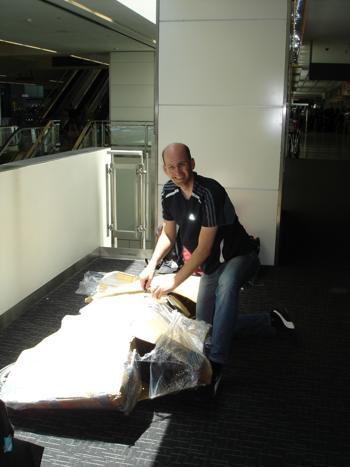 |
| start unwrapping the bike at SF airport |
 |
| the recumbent bike |
We had something to eat at the airport (a salad!J ) and then we took the subway halfway back to SF at 15:20. At 15:50 we arrived in Daly City.
Fortunately we had kept the bus map of SF (as everybody can see: we were really well preparedJ) and this map also included a more or less detailed road network of the Daly City roads. So we knew we had to find John Daly Boulevard and this road would lead us to Highway 1. After getting out of the station we saw a traffic sign showing us the direction to the Boulevard we were looking for. At that point I was a little bit scared of the whole situation. My bike was kind of heavy (when I took the flight to SF the airport scales showed 13.2 kg for the 3 panniers in total plus about 6-7 kg for my backpack). My backpack was more lightweight now but the panniers heavier and when I was walking the bike it took me some effort to keep the bike steady: the handlebar was easy to take off and I had to lean against it all the time to prevent it from falling over to one side. As I already mentioned I was kind of scared to start riding this unknown and heavy loaded bike at a very heavy auto traffic Boulevard… I practiced a little bit in front of the station and then we started. I preferred the sidewalk and later we tried to ride our bikes on parallel streets to the Boulevard but sometimes we were unlucky and there was no way out of the street anymore. When we finally saw and heard Highway 1 we couldn’t use it for a while (forbidden for bikes) and so we had to found our way (with the aid of the bus map and Christoph’s book where the route was described in words but not shown) through a residential area.
 |
| up and downhill in a residential area |
 |
| first glimpse at the Ocean |
 |
| 2nd glimpse at the Pacific Ocean |
From the subway station to Highway 1 it was a difficult route for the beginning: always up and down (one to two arrow hills), no detailed map but luckily Christoph’s sense of direction helped us to overcome a description-bug in the book. At the end of that hilly part I was walking my bike uphillJ
When finally the “flat” part begun I started getting used to riding a bike with all that weight on the rack. When we took a break we met a couple living in the US but originally from the Netherlands who were interested in Christoph’s bike and who wished us a good trip. In the guy’s opinion it wasn’t difficult to find our way: “just stay on the Highway 1J ” and he mentioned that most of the time the shoulders would be wide enough but later on that day there would be a winding road going up for a while with narrow lanes, road work going on and without shoulders. I only thought: UP again….
When we reached the winding road I decided to walk my bike uphill and Christoph rode his at 4 km/h just behind me. The lanes were more or less in the shade, they were narrow as we already knew and I was happy when we finally reached the summit of the hill where we took another break.
 |
| uncomfortable way up |
 |
| break on the peak |
 |
| finally on the Highway, Ocean-view included |
We arrived at our Inn at 20:15 and were happy that we had just finished our first stage!J
(I need to mention that this was the beginning of my first bike tour lasting longer than 3 days and carrying more than 10 kg with me)
Tour stage
Tour stage: Daly City to El Granada
Distance: 32.22 km
Total time (breaks included): 15:50 - 20:15
Average speed: 11.05 km/h
Real running time: 2h 54 min
When we had taken a shower it was already too late for most of the restaurants around the Inn (closing time was around 21:00 or 21:30). Thus we had no choice and ate in the only restaurant that was still open: a seafood restaurant (I had very delicious shrimps!!J Yippi!) but Christoph also found a non-seafood dish.
We were finished at 23:00 and lay in bed at 23.15.
Keine Kommentare:
Kommentar veröffentlichen